8/28/2017
UPDATE 8/27 6 p.m.: The Brazos River is anticipated to approach 59 feet early this week, which is three feet over the 100-year flood event. As a precaution, Missouri City officials are urging residents to prepare in the event that these levels are reached. There are no evacuations currently in place; residents will be notified if the shelter in place order is changed.
In anticipation of the river reaching flood stage, levee operators will have to close flood gates as the river rises. When the gates are closed, levee operators will begin using pumps to remove rainfall that falls within the levees.
The US National Weather Service Houston-Galveston Texas is forecasting rain amounts that may exceed the capacity of the pumps. Should this occur, the drainage channels and storage areas will fill up, storm drains will back up and streets will flood, essentially holding water as they're designed to do during extreme conditions. The duration and intensity of rainfall will determine the impact for communities within these areas.
Crews are putting blocks at major thoroughfares only at this time; other areas will be blocked if necessary. Again, residents are under shelter in place orders; roads are flooding, and cars are stalling. TURN AROUND, DONT DROWN. If you have more questions, need to report property damage or want to notify staff of area flooding, please call 281.403.5801. Call 911 during an emergency.
UPDATE 8/27 3:30 p.m.: Rumors are spreading on social media that residents' water will be shut off. There are no reports at this time of water being shut off for anyone in Missouri City.
Fort Bend County has upgraded the voluntary evacuation order for certain residents in low-lying areas surrounding the Brazos River to a mandatory evacuation order. Missouri City has NOT issued any evacuations at this time; residents are still requested to shelter in place and avoid all travel at this time.
WCA Waste will NOT have pick-up tomorrow. Services will resume based on weather conditions. Please keep streets clear of trash/recycling bins and waste.
Due to widespread flooding and the continuing threat of more severe weather, the Fort Bend Independent School District will remain closed through Tuesday, Sept. 5. All FBISD staff members and families are urged to continue monitoring local media and follow the advice of emergency management officials.
UPDATE 8/27 Noon: The Brazos River is expected to approach 55 feet early this week. In anticipation of the river reaching flood stage, levee operators will have to close flood gates as the river rises. When the gates are closed, levee operators will begin using pumps to remove rainfall that falls within the levees.
The US National Weather Service Houston-Galveston Texas is forecasting rain amounts that may exceed the capacity of the pumps. Should this occur, the drainage channels and storage areas will fill up, storm drains will back up and streets will flood, essentially holding water as they're designed to do during extreme conditions. The duration and intensity of rainfall will determine the impact for communities within these areas.
The shelter in place order remains in effect for Missouri City. Crews are putting blocks at major thoroughfares only at this time; other areas will be blocked if necessary. Again, residents are under shelter in place orders; roads are flooding, and cars are stalling. TURN AROUND, DONT DROWN. If you have more questions, need to report property damage or want to notify staff of area flooding, please call 281.403.5801. Call 911 during an emergency.
UPDATE 8/27 6 a.m.: A Flash Flood Emergency is in effect for Fort Bend County until 10:45 a.m., Aug. 27; the county also remains under a Flash Flood Watch until 7 p.m. Aug. 30. Heavy rainfall is anticipated through the remainder of the weekend into late next week; the National Weather Service is predicting 15 to 25 additional inches of rain for this area through the five-day forecast.
Emergency officials advise residents to shelter in place and not to travel. Several streets and roads are impassable due to high water. Do not risk your safety or the safety of first responders.
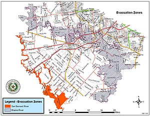
The Brazos River is expected to reach record levels as the storm moves slowly across the region. Street flooding is expected; no Missouri City evacuations have been issued at this time. Residents can monitor the Fort Bend County Drainage District’s Interactive Map for the Brazos River for up-to-date gauge readings: Click Here.
An interactive GIS map is available now for residents to track road blocks and high water areas: Click Here. As the storm approaches, updates will be made to the map. Residents may also submit their own photos to the City’s interactive photo map! Visit the new GIS site and view other photos throughout the City: Click Here
A confirmed tornado hit the 2200 block of Texas Parkway in the Missouri City area. No major injuries or fatalities have been reported and the extent of area property damage is uncertain at this time.
Fort Bend County has partnered with the Red Cross and Sacred Heart Church in Richmond and opened a temporary shelter in the church at 507 South 4th Street; residents affected and displaced by flooding related to Harvey will be assisted by this shelter.
A list of Harvey Resources/FAQ's is available on the City’s website, www.missouricitytx.gov, and the City’s Emergency Management website, www.missouricityready.com.
Residents with additional questions may call the citizen hotline at 281.403.5801 while the EOC remains activated; residents should use the hotline to report any damage to their property.