4/9/2024
Another round of severe weather is slamming parts of the South and Mississippi Valley on Tuesday, less than a week after a powerful storm system that swept through parts of the region killed at least three people.
Heavy rain, strong winds and dangerous thunderstorms began Monday in an area from Texas to Alabama. Around 4 to 6 inches of rain had already fallen in parts of northeast Texas, northwest Louisiana and southwest Arkansas, prompting flash flood warnings Tuesday.
Continuing storms are forecast to unleash flooding, damaging winds, large hail and tornadoes Tuesday through Thursday, threatening tens of millions of Americans from eastern Texas to the Southeast coast.
Of particular concern was the threat of tornadoes of at least EF2 strength in an area stretching from eastern Texas to the Florida Panhandle through Wednesday night.
Close to 9 million people in parts of eastern Texas and western Louisiana have a Level 3 of 5 risk of severe thunderstorms Tuesday. That includes Houston and Austin.
There will be multiple rounds of severe storms throughout the day Tuesday, but the danger builds later in the afternoon and evening as the chance for tornadoes and damaging winds grows.
The storms will also bring heavy rain over the same areas. Widespread rainfall totals of 3 to 6 inches are expected across parts of the southern Mississippi Valley Tuesday into Wednesday with more than 8 inches possible in localized areas. Flood watches have already been issued for much of the region through Wednesday evening.
In parts of Mississippi and Louisiana, the several rounds of heavy rain expected between Tuesday and Wednesday will likely lead to flash flooding and minor to moderate river flooding, the National Weather Service in Jackson warned.
In some areas just west of Jackson, up to 10 inches of rain are possible, with the potential of flooded roads and structures, the weather service said.
Texas Gov. Greg Abbott earlier this week directed the state’s emergency management division to mobilize emergency response resources ahead of the severe weather and urged the thousands of Americans who poured into the state to witness Monday’s solar eclipse to heed weather warnings from officials.
Wednesday could bring the worst of the storms
The most significant storm threat could come Wednesday and will be ongoing during the morning hours as storms from overnight Tuesday push east.
The Storm Prediction Center warned of “numerous” severe thunderstorms Wednesday, including “many tornadoes, some of which should be strong (EF2-EF3 caliber)” and damaging wind gusts topping 75 mph.
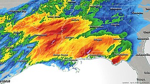
A Level 4 of 5 threat of severe storms stretches from eastern Louisiana to western Alabama, including Baton Rouge and Jackson. These are the areas most at risk for strong tornadoes, but some will also be possible in Level 3 of 5 areas, including New Orleans and Mobile.
A more isolated tornado and damaging wind risk is expected in Level 2 of 5 threat areas, including Birmingham, Montgomery and Huntsville, Alabama.
Flash flooding could occur in all areas, especially parts of eastern Mississippi and central and southern Alabama. A Level 3 of 4 threat of flooding rain covers the area, the Weather Prediction Center said. Rain could drop at nearly 2 inches per hour across Alabama’s I-20/I-59 interchange.
By Thursday, the severe storm threat shifts further into the Southeast while storms also pummel the Ohio Valley. Both regions face Level 2 of 5 threats for damaging winds and a potential tornado or two. The flood threat on Thursday spans from the Southeast to New England, with the most severe conditions anticipated across the Appalachian Mountains.