1/8/2019
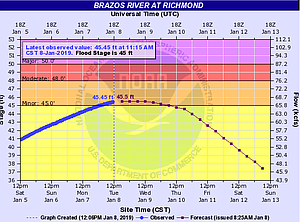
The National Weather Service has issued a flash flood warning for the Brazos River in Richmond until Thursday, Jan. 10 with water level at 45.45 feet at 11:15 a.m. today (Jan. 8). This has caused minor flooding in some areas including portions of the Edible Arbor Trail on Oyster Creek in Missouri City.
Staff has evaluated this section and closed both sides of the trail under FM 1092 (Murphy Road) with barricades until the water recedes. Residents are advised to avoid these high water areas and use caution while walking on the trail and in Mosley Park.
According to the Fort Bend Office of Emergency Management, the river’s forecast crest level is about 10-feet lower than both Hurricane Harvey and Memorial Day in 2016, and 5-feet lower than Memorial Day and Tax Day flooding in 2015. For details on current water levels, click this link: http://bit.ly/2sgyd2P.
Residents are encouraged to avoid traveling through flooded areas, and remember: Turn Around, Don’t Drown. City staff is monitoring area waterways; if there is a concern in your community, please call 281.403.8700.
Residents are also encouraged to sign up for emergency alerts on www.MissouriCityReady.com and Twitter—@MissouriCityEM.
For updates, please watch the City website: www.missouricitytx.gov, like us on Facebook—fb/MissouriCityTX, follow us on Twitter, Instagram, Snapchat—@MissouriCityTX and Nextdoor, watch Missouri City Television (Ch. 16 on Comcast and Ch. 99 on AT&T U-verse) or download the MCTX Mobile app (available for free in Google Play and the Apple app store).